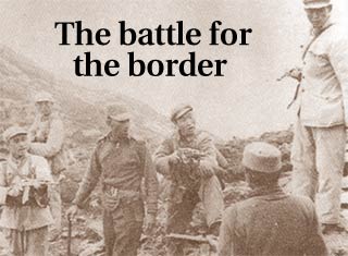
Part I: The Great India-China Game
Part III: Peace with China
The next major development with China and Tibet was when the British called for a conference at Simla in October 1913. The Chinese attended reluctantly, but the Tibetan authorities came quite eagerly as they were now engaged in conflict with their Chinese suzerains. Henry McMahon, then foreign secretary to the 'government of India,' led the British delegation. McMahon was some sort of an expert at drawing boundary lines, having spent two years demarcating the Durand Line at the northwest frontier.
The boundary that followed was the now famous McMahon Line. This boundary now extended British India up to the edge of the Tibetan plateau. It was not really a cartographers delight as it violated several rules of boundary demarcation. But it was an ethnic boundary in the sense that the area, except for the Tawang tract, was non-Tibetan in character.
The Chinese soon repudiated the Simla Convention and thus the McMahon Line. All through this period, the British never challenged Chinese suzerainty over Tibet. The new boundary was not made effective till Olaf Caroe, an ICS officer, urged the British authorities to do so in 1935. Thus, in 1937, the Survey of India for the first time showed the McMahon Line as the official boundary. But confusion still abounded.
In 1938, the Survey of India published a map of Tibet, which showed the Tawang tract as part of that country. Even the first edition of Jawaharlal Nehru's Discovery Of India showed the Indo-Tibetan boundary as running at the foot of the hills. The Tibetans did not accept this 'annexation' of the Tawang tract and challenged the British attempts to expand their government into this area. But they tacitly accepted the rest of the McMahon demarcation. It is clear that, but for the Tawang tract, there is little basis for the Chinese claim on the whole of Arunachal Pradesh. Even the claim they might have on the Tawang tract is rendered invalid in the sense that it becomes a geographical anachronism and incompatible with India's security interests.
The Japanese thrust towards India in World War II gave urgency to the British need to fix this boundary firmly and securely. Thus, in 1944, J P Mills, the then government's advisor on tribal affairs, established a British administration in the entire belt from Walong in the east to Dirang Dzong in the west. Several posts of the Assam Rifles were established and soon Tibetan government officials were packed off from the Tawang tract also.
)
This was the state of the Great Game when the British left India. In 1949, the Communists came to power in China and shortly thereafter the People's Republic announced its army would be moving into Tibet. India reacted by sending the Chinese a diplomatic note. Soon after receiving this angry protest, the Chinese occupied Tibet. The Chinese said: 'Tibet is an integral part of China and the problem of Tibet is a domestic problem of China. The Chinese People's Liberation Army must enter Tibet, liberate the Tibetan people and defend the frontiers of China.' India had hoped to persuade the Chinese to desist by offering to take up their case for membership in the UN in place of the Kuomintang Chinese left on Formosa. The Chinese rejected this absurd quid pro quo and said these two issues were unconnected.
The purpose of this laborious recitation of the events of nearly a century-and-a-half of the Great Game is to only show that borders were either never clearly demarcated or established. Lines kept shifting on maps as political contingencies arose. The Indian people were, for this entire period, passive spectators to these cartographic games.
In 1947, the British finally left India. Our choice then was to either call an end to the Great Game or continue playing it with all the intensity and commitment it called for. We did neither. When the Chinese Communists occupied Tibet, we acquiesced. Neither did we firmly move into the areas claimed by the British as Indian territory, particularly in the western sector. How well we looked after territory we claimed as our own is seen by the fact that, in the early 1950s, the Chinese had built a road connecting Tibet to Sinkiang across the Aksai Chin and we did not have a clue about it for several years.
The Indian government did move into the Tawang tract in force in 1951, overriding Chinese/Tibetan protests. In this sector, at least, it was clear that the Indian government was firm about its control of all the territory claimed by the British. There are several signs that indicate the Chinese too seem to have accepted the McMahon Line as the boundary in this sector.
The situation in the western sector was entirely different. Here no definite British Indian boundary line existed. The only two points accepted by both sides were that the Karakoram Pass and Demchok, the western and eastern ends of this sector, were in Indian territory. Opinions on how the line traversed between the two points differed.
India's boundary was inclined towards the Johnson claim line whereas as the Chinese, having built their road through the Aksai Chin, naturally preferred an alignment closer to the McCartney/MacDonald line of 1899. The Chinese claim line however went further west and included the Chip Chap valley, Samzungling, Kongka La, Khurnak Fort and Jara La. More importantly, as far as the Great Game was concerned, the Chinese had occupied all this territory by the early 1950s.
This is how matters were by the end of 1952 and by and large how things are today. The Chinese hold all territory, give or take some, within their claim line in Ladakh. In the east, India holds most of the territory below the McMahon line give or take some. These de facto boundaries could have been a basis for a permanent settlement of our boundaries. But we did not pursue it, though there are indications from time to time that the Chinese might want to settle on this basis.
Now the question that arises is: Why did the Government of India not extend its control to the boundaries it claimed in the western sector as it did in the east? This was mostly due to the terrain. The boundary claimed lies beyond two high mountain ranges and is logistically and militarily indefensible. Besides, the Chinese were already in control of much of the area by 1951. The question then is: Why did the government of India not make serious diplomatic or military efforts to assert control over territories it believed was ours?
The answer obviously lies in the fact that, legally, there was not a very good case. Besides, the military price this barren uninhabited windswept desolation would demand did not make it a worthwhile cause. Despite all this, there abounded the zealous spirit with which recently freed nations regarded their inherited boundaries that were often without regard to geography, ethnicity and history. Even in 1954, the most advanced Indian post was at Chushul. Barring a couple of patrols to Lanak La, no attempt was made to show the new flag. Even Lanak La was well south of Aksai Chin and short of the Sinkiang-Tibet highway, which passed east of it at that point.
The main rule of the Game for the previous 150 years was that it be played as quietly and surreptitiously as possible. In the 1950s, these rules still seemed to prevail. The two contesting governments decided to keep the lid on the problems while jockeying around for local advantages. On the surface it was all 'Hindi-Chini bhai-bhai' and the practice of the Panchsheel philosophy. Underneath was the realisation the titles to large tracts of territory under the control of both parties were under dispute. The lid on this roiling cauldron blew away when in March 1959 the Dalai Lama fled to India and was given political asylum.
Part I: The Great India-China Game
Part III: Peace with China
Image: Dominic Xavier